
CAD Geodesy Assistant is an addin for your CAD system extending the geodetic functionality through a set of commands and a simple dialog based user interface. These extra commands are availble to enter at the CAD prompt hence they can be added to your own customisation of the CAD user interface.
This addin is currently available for the following CAD versions:
Contact CADology to request your copy now!
The commands available in CAD are prefixed with 'cg' to assist the user with the command selection of this addin, simply enter cg at the CAD command prompt.
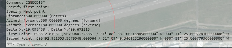
This is a CAD command that will ask the user to select two points so that geodetic information can be displayed to the CAD command window. The following information is displayed:
This command work in a simular way to the MAPDIST command in MAP3D. The number of decimal places depends on the value of the CAD LUPREC system variable. Below is an example of the command line output:
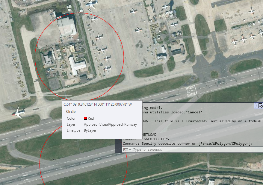
This is a CAD command that toggles if Latitude/Longitude coordinates are displayed in the CAD tooltip when the cursor is above an entity. The list below shows the entity type along with which keypoint coordinates are shown:
The number of decimal places depends on the value of the CAD LUPREC system variable. Below is an example of the tooltip showing the geographical coordinate of the centre of the circle entity:
This command will open the geodectic calculations dialog, here there are many different types of tools for Lat/Long calculations.
This dialog is fully interaction with CAD allowing for coordinate points to be selected from the CAD drawing.
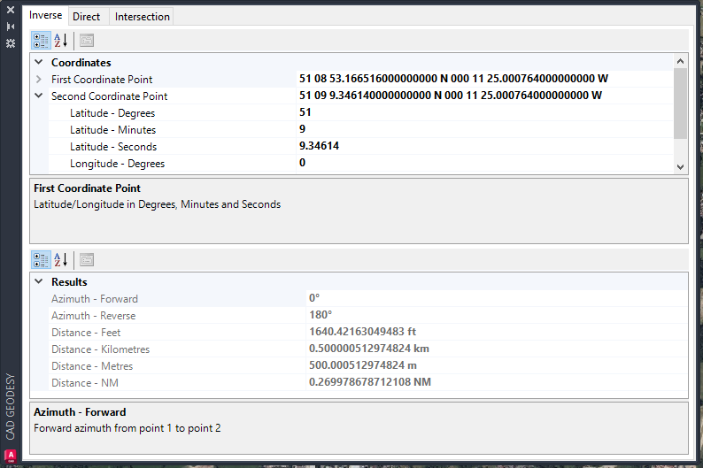
A series of tabs displayed at the top of the dialog offer the selection of calculations, simply click on the tab to display the properties. The current list of calculations are listed below.
Coordinates - By clicking on a coordinate, an ellipsis button (...) appears on the right hand side. If this is clicked, then the user can select a point from the drawing and the lat/long value will be display within the relevant property on the dialog grid.
Geodetic Calculations:
Inverse - Select two coordinates to obtain distance and azimuth data.
Direct - Enter an coordinate, distance and azimuth to computer the resultant destination coordinate.
Intersection - Calculates the intersection coordinate from two geodetic lines.
This command will display the version numbers of CAD Geodesy Assistant and the suppporting DLL known as FPAssistant (this does all the geodetic math).
This will also display the details of the coordinate system assigned to the current DWG in XML which means it can be copied from the CAD command window to WIndows clipboard.
Currently this plugin for both AutoCAD and BricsCAD is available direct from CADology, if you like to try the CAD Geodesy Assistant then please make contact or visit the group on LinkedIn
Or contact CADology to receive your copy direct, in the future the plugin will be available from the stores of AutoCAD and BricsCAD.

CADology © 2022 All Rights Reserved